बिहार मौसम सेवा केंद्र
योजना एवं विकास विभाग, बिहार सरकार
| Zone | Districts |
|---|---|
| North-West Zone | East Champaran, Gopalganj, Siwan, Saran, and West Champaran |
| North-Central Zone | Darbhanga, Madhubani, Muzaffarpur, Samastipur, Sheohar, Sitamarhi and Vaishali |
| North-East Zone | Araria, Kishanganj, Madhepura, Purnea, Saharsa and Supaul |
| South-Central Zone | Begusarai, Gaya, Lakhisarai, Nalanda, Nawada, Patna and Sheikhpura |
| South-West Zone | Arwal, Aurangabad, Buxar, Bhojpur, Jehanabad, Kaimur (Bhabua) and Rohtas |
| South-East Zone | Banka, Bhagalpur, Jamui, Katihar, Khagaria and Munger |
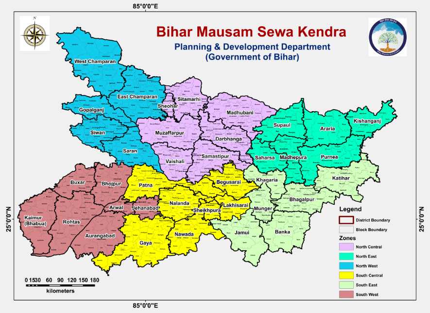
Geographical zones of Bihar
| Type | Description |
|---|---|
| One or two spells of rain | In a 24 hrs time, rainfall occurring with a frequency of 1–2 spells. |
| A few spells of rain | In a 24 hrs time, rainfall occurring with a frequency of more than 2 spells but with well-defined dry spells in between. |
| Intermittent rain | In a 24 hrs time, rainfall occurring with a frequency more than "A Few Spells" but is discontinuous and without the character of a shower. |
| Drizzle | Liquid precipitation in the form of water drops of very small size (radius between ~100 and 500 µm). |
| Rain | Liquid precipitation in the form of water drops of radius between ~500 and 2500 µm. |
| Shower | Solid or liquid precipitation from a vertically developed cloud; often characterised by short duration and rapid fluctuations of intensity (radius >2500 µm). |
| Hailstorm | Solid precipitation in the form of balls or pieces of ice (hailstones) with diameters ranging from 5 to 50 mm or more. |
| Thunderstorm | One or more sudden electrical discharges manifested by a flash of light (lightning) and a sharp rumbling sound (thunder). |
| Duststorm | An ensemble of particles of dust or sand energetically lifted to great heights by a strong and turbulent wind. Visibility below 1000 m. |
| Mist | A phenomenon of small droplets suspended in air. |
| Dew | Condensation of water vapour on a surface when temperature is reduced by radiational cooling to below the dew-point of the air in contact with it. |
| Fog | A phenomenon of small droplets suspended in air; visibility is one kilometre or less. |
| Frost | Occurs when the temperature of the air in contact with the ground or at thermometer-screen level is below the freezing-point of water. |
| Haze | An atmospheric phenomenon where dust, smoke and other dry particles obscure the clarity of the sky. |
| Smog | Smoke and fog together reduce the visibility. |
| Squally weather | Occasional or frequent squalls with rain or persistent strong gusty winds (mean wind speed ≥20 knots) with rain; associated with low pressure systems or monsoon onset. |
| Visibility | The greatest distance that a prominent object can be seen and identified by unaided, normal eyes. |
| Type | Description |
|---|---|
| Nowcasting | A short range forecast having a lead time/validity of less than 24 hrs. |
| Short range forecasts | Forecasts having a lead time/validity period of 1 to 3 days. |
| Medium range forecasts | Forecasts having a lead time/validity period of 4 to 10 days. |
| Long range / Extended Range forecasts | Forecasts having a lead time/validity period beyond 10 days. Usually issued for a season. |
| Local Forecast | Whenever any weather phenomenon is expected, its intensity, frequency and time of occurrence is indicated. Valid for a radius of 50 km around the station; updated 4 times a day. |
| Term | Description |
|---|---|
| Cyclonic Circulation (Cycir) | Atmospheric wind flow in upper levels associated with any low-pressure system. Counter-clockwise in the Northern Hemisphere, clockwise in the Southern Hemisphere. |
| Anticyclonic Circulation | Atmospheric wind flow in upper levels associated with any high-pressure system. Clockwise in the Northern Hemisphere, counter-clockwise in the Southern Hemisphere. |
| Low Pressure Area (LOPAR) | Area in the atmosphere where pressures are lower than surrounding regions at the same level; represented on a synoptic chart by one closed isobar (surface wind <17 Kts at sea). |
| Depression | Intense low-pressure system with 2–3 closed isobars at 2 hPa interval; wind speed 17–27 Kts at sea. |
| Deep Depression | Intense low-pressure system with 2–3 closed isobars at 2 hPa interval; wind speed 28–33 Kts at sea. |
| Cyclonic Storm | Intense low-pressure system with >4 closed isobars at 2 hPa interval; surface wind speed 34–47 Kts. |
| Severe Cyclonic Storm | Surface wind speed 48–63 Kts. |
| Very Severe Cyclonic Storm | Surface wind speed 64–119 Kts. |
| Super Cyclonic Storm | Surface wind speed ≥120 Kts. |
| Western Disturbance | Weather disturbance originating over the Mediterranean Sea, Caspian Sea and Black Sea, moving eastwards across north India; shows as cyclonic circulation/trough in mid and lower tropospheric levels. |
| Western Depression | Weather system originating over the Mediterranean/Caspian/Black Sea approaching northwest India; defined by two or more closed isobars on the surface. |
| Induced Low | Under the influence of a western disturbance, a low sometimes develops to the south of the system. |
| Induced Cyclonic Circulation | A cyclonic circulation sometimes developing to the south of a western disturbance. |
| Trough | A line or curve along which atmospheric pressure is minimum; pressure increases on both sides. |
| Trough in westerlies | A moving wave perturbation in mid-latitude regions moving west to east, affecting northern parts of India. |
| Trough in easterlies | A moving wave perturbation in the equatorial easterly wave, moving east to west. |
| Easterly Waves | A shallow trough disturbance in the easterly current of the tropics; its westward passage is followed by intensified cloudy, showery weather. Affects southern peninsular India. |
| Shear Line | A line across which there is an abrupt change in the horizontal wind component; a line of maximum horizontal wind shear. |
| Ridge | An elongated area of relatively high atmospheric pressure associated with maximum anticyclonic curvature of wind flow. |
| Wind-discontinuity | A line across which there is an abrupt change in wind direction. |
| Troposphere | The atmospheric layer in which all significant weather phenomena occur; characterised by decreasing temperature with height. |
| Lower troposphere level | Part of the troposphere up to 2.1 km above mean sea level (a.s.l.). |
| Mid troposphere level | Part of the troposphere from 2.1 km a.s.l. but below 7.6 km a.s.l. |
| Upper troposphere level | Part of the troposphere from 7.6 km a.s.l. to the height up to which temperature decreases with height. |
| Part of Day | IST | UTC |
|---|---|---|
| Early hours of (date) | 0000 – 0400 hrs | 1830 – 2230 hrs |
| Early morning | 0400 – 0600 hrs | 2230 – 0030 hrs |
| Morning | 0600 – 0800 hrs | 0030 – 0230 hrs |
| Forenoon | 0800 – 1200 hrs | 0230 – 0630 hrs |
| Around noon | 1100 – 1300 hrs | 0530 – 0730 hrs |
| Afternoon | 1200 – 1600 hrs | 0630 – 1030 hrs |
| Evening | 1600 – 2000 hrs | 1030 – 1430 hrs |
| Night | 2000 – 2400 hrs | 1430 – 1830 hrs |
| Condition | Octa Coverage |
|---|---|
| Clear sky | 0 Octa |
| Mainly clear | 1–2 Octa of sky covered |
| Partly cloudy | 3–4 Octa of sky covered |
| Generally cloudy | 5–7 Octa of sky covered |
| Cloudy | >7 Octa of sky covered |
Intensity of Rainfall
| Term | Amount (mm / 24 hrs) |
|---|---|
| No Rain | 0.0 |
| Very Light Rain | 0.1 – 2.4 |
| Light Rain | 2.5 – 15.4 |
| Moderate Rain | 15.5 – 64.4 |
| Heavy Rain | 64.5 – 115.5 |
| Very Heavy Rain | 115.6 – 204.4 |
| Extremely Heavy Rain | ≥ 204.5 |
| Exceptionally Heavy Rain | When amount is near the highest recorded rainfall at/near the station for the month or season (must exceed 12 cm). |
Weekly / Seasonal Rainfall Distribution — Regional Scale
| Term | % Departure from Normal |
|---|---|
| No Rain | −100% |
| Large Deficient | −60% or less |
| Deficient | Between −59% to −20% |
| Normal | Between −19% to +19% |
| Excess | Between +20% to +59% |
| Large Excess | +60% or more |
Rainfall Distribution — All India Scale
| Term | Condition |
|---|---|
| Normal | % departure of realised rainfall is within ±10% of the Long Period Average. |
| Below Normal | % departure is <−10% of the Long Period Average. |
| Above Normal | % departure is >+10% of the Long Period Average. |
| All India Drought Year | Rainfall deficiency >10% and 20–40% of the country is under drought conditions. |
| All India Severe Drought Year | Rainfall deficiency >10% and spatial coverage of drought is >40%. |
Spatial Distribution of Rainfall
| Distribution | No. of Places | Station Coverage |
|---|---|---|
| Isolated | One or two places | <25% of stations get rainfall. |
| Scattered | At a few places | 26–50% of stations get rainfall. |
| Fairly Widespread | At many places | 51–75% of stations get rainfall. |
| Widespread | At most places | 76–100% of stations get rainfall. |
| Dry | — | No station reported rainfall. |
| Term | Description |
|---|---|
| Monsoon | The seasonal reversal of winds and associated rainfall. Derived from Arabic "Mausim". The annual oscillation of the Sun between the Tropics of Cancer and Capricorn causes oscillation in temperature, pressure, wind, cloudiness, and rain. |
| Southwest Monsoon | The southwesterly wind flow occurring over most parts of India and Indian Seas from June to September. |
| Onset of Southwest Monsoon | Commencement of rainy season with establishment of monsoon flow. Normal dates: South Andaman Sea — 20 May; Kerala — 1 June; Mumbai — 10 June; New Delhi — 29 June; Entire country — 15 July. Bihar: 15 June. |
| Withdrawal of Southwest Monsoon | Cessation of southwest monsoon rainfall. Normal date from extreme west Rajasthan — 15 September. Bihar: 30 September. |
| Northeast Monsoon | With withdrawal of southwest monsoon from northern/central India by first half of October, winds change from southwesterly to northeasterly (October–December). Major rainfall period for south peninsula; contributes ~60% of annual rainfall in coastal Tamil Nadu. |
Terms used during Southwest Monsoon Season (June – September)
| Term | Condition |
|---|---|
| Weak / Subdued Monsoon | Rainfall less than half the normal (land); wind speed up to 12 knots (sea). |
| Normal Monsoon | Rainfall half to less than 1½ times the normal (land); wind speed 13–22 knots (sea). |
| Active Monsoon | Rainfall 1½–4 times the normal; at least two stations with ≥5 cm (west coast) or ≥3 cm (elsewhere); fairly widespread to widespread; wind speed 23–32 knots (sea). |
| Vigorous Monsoon | Rainfall >4 times the normal; at least two stations with ≥8 cm (west coast) or ≥5 cm (elsewhere); widespread; wind speed ≥33 knots (sea). |
| Northern Limit of Monsoon (NLM) | A line delineating regions where monsoon has advanced from regions where it is yet to set in. |
| Axis of Monsoon Trough | A NW–SE oriented trough across the northern plains. Normal position passes through Ganganagar–Allahabad–Kolkata to Head Bay. |
| Break Monsoon | Monsoon trough shifts northwards close to the Himalayan foothills, causing drastic reduction in rainfall outside foothills and southernmost Peninsula. |
| Off-shore Trough | The trough along the west coast generally running from Gujarat to Kerala coasts; generally seen from the surface to 0.9 km a.s.l. |
| Term | Description |
|---|---|
| Temperature | The condition of a body that determines its ability to communicate heat to or receive heat from other bodies. Measured by thermometer; India Meteorological Department uses the Celsius scale. |
| Air Temperature | Temperature measured in an enclosed space with free airflow, not directly exposed to sunlight, with the thermometer at 1.2 m above the surface. |
| Maximum Temperature | The highest air temperature recorded in a day. |
| Minimum Temperature | The lowest air temperature recorded in a day. |
| Dew Point Temperature | The temperature to which moist air must be cooled (at constant pressure and moisture content) for condensation to occur. Lower dew point indicates lesser moisture content. |
| Freezing Point | The constant temperature at which solid and liquid forms of pure water are in equilibrium at Standard Atmospheric Pressure. |
24-hr Temperature Change Nomenclature — Maximum Temperature
a) When normal maximum temperature is 40°C or below
| Nomenclature | Past 24-hr change |
|---|---|
| Little change | −1°C to +1°C |
| Rise | 2°C |
| Appreciable rise | 3°C to 4°C |
| Marked rise | 5°C to 6°C |
| Large rise | 7°C or more |
b) When normal maximum temperature is more than 40°C
| Nomenclature | Past 24-hr change |
|---|---|
| Little change | −1°C to +1°C |
| Rise | 2°C |
| Marked rise | 3°C to 4°C |
| Large rise | 5°C or more |
24-hr Temperature Change Nomenclature — Minimum Temperature
a) When normal minimum temperature is 10°C or more
| Nomenclature | Past 24-hr change |
|---|---|
| Little change | +1°C to −1°C |
| Fall | −2°C |
| Appreciable Fall | −3°C to −4°C |
| Marked Fall | −5°C to −6°C |
| Large Fall | −7°C or less |
b) When normal minimum temperature is less than 10°C
| Nomenclature | Past 24-hr change |
|---|---|
| Little change | +1°C to −1°C |
| Fall | −2°C |
| Marked Fall | −3°C to −4°C |
| Large Fall | −5°C or less |
Heat Wave Criteria
Other Temperature-Related Terms
| Term | Description |
|---|---|
| Normal | Departure of min/max temperature from normal is ±1°C. |
| Above normal | Departure is +2°C. |
| Appreciably above normal | Departure is +3°C to +4°C (normal max ≤40°C). |
| Markedly above normal | Departure is +5°C to +6°C (normal max ≤40°C). |
| Hot Day | Max temperature ≥40°C and min temperature ≥5°C above normal, but not satisfying heat wave criteria. |
| Heat Wave | Departure of max temp from normal: +4°C to +5°C or more (where normal max >40°C); +5°C to +6°C (where normal max ≤40°C). Also declared when actual max ≥45°C regardless of normal. |
| Severe Heat Wave | Departure of max temp from normal: +6°C or more (normal max >40°C); +7°C or more (normal max ≤40°C). |
| Hot Wind (Loo) | Hot wind over the plains of northwest India that reduces moisture causing dehydration; prolonged exposure may prove fatal. |
| Cold Day | Declared when maximum temperature is ≤16°C in plains (foggy winter conditions with max temperature much below normal). |
| Cold Wave | Departure of wind chill effective minimum temperature (WCTn) from normal min: −5°C to −6°C (where normal min >10°C); −4°C to −5°C elsewhere. Also when WCTn <0°C regardless of normal min. |
| Severe Cold Wave | Departure of WCTn from normal min: −7°C or less (normal min >10°C); −6°C or less elsewhere. |
| Term | Description |
|---|---|
| Wind | Atmospheric motion characterised by direction and speed. The direction of the wind is the direction from which it approaches the station (e.g., Northerly wind — wind approaching from North). |
| Calm | The absence of apparent motion in the air. |
| Gales | A very strong wind (34 to 47 knots). |
| Squall | A sudden increase of wind speed by at least 3 stages on the Beaufort Scale, the speed rising to force 6 or more, and lasting at least one minute. |
| Gust | A rapid increase in the strength of the wind relative to the mean strength at the time. |
| Term | Description |
|---|---|
| Clouds (Low/Medium/High) | Aggregates of very small water droplets, ice crystals, or a mixture, with base above the earth's surface. High clouds (5–13 km): Ci, Cc, Cs. Medium clouds (2–7 km): Ac, As, Ns. Low clouds (0–2 km): Sc, St, Cu, Cb. |
| Condensation | The process of formation of a liquid from its vapour; in meteorology, the formation of liquid water from water vapour. |
| Convection | A mode of heat transfer within a fluid involving movement of substantial volumes of the substance; of fundamental importance in effecting vertical exchange of heat and other air-mass properties throughout the troposphere. |
| Freezing-Level | The lowest height above mean sea level at which, for a given place and time, the air temperature is 0°C. |
| Isobar | A line of constant (atmospheric) pressure. |
| Isohyet | A line of constant rainfall amount. |
| Isotach | A line of constant wind speed. |
| Isogon | A line of constant wind direction. |
| Isotherm | A line of constant temperature. |
| Streamline | A line parallel to the instantaneous direction of the wind vector at all points along it. |
| Jet Stream | A fast narrow current of air, generally near the tropopause, characterised by strong vertical and lateral wind shears; thousands of kilometres in length, hundreds in width, a few kilometres in depth. |
| Latent Heat | The quantity of heat absorbed or emitted, without change of temperature, during a change of state of unit mass of a material. Important in meteorology for ice–water–vapour state changes. |
| Radiation | The transmission of energy by electromagnetic waves. |
| Land and Sea Breezes | Local winds caused by unequal diurnal heating and cooling of adjacent land and water surfaces. Sea breeze blows onshore during day (land warmer); land breeze blows offshore at night (land cooler). |
| Tornado | A violent, rotating column of air in contact with both the surface of the earth and a cumulonimbus cloud. Often visible as a condensation funnel encircled by a cloud of debris. |
| Water Spout | An intense columnar vortex (usually funnel-shaped cloud) over a body of water connected to a cumuliform cloud. Generally a non-supercell tornado over water; weaker than most land counterparts. |
| Pressure | The weight of the air column above unit area at a given point. Measured by mercury barometer; expressed in hPa (1 hPa = 10⁶ Newton/m²). |
| Precipitation | The depth to which rain or snow would cover the surface (if no loss by evaporation/runoff/infiltration, with snow/ice melted). Expressed in mm or cm. |